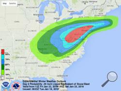
WASHINGTON (AP) — Tens of millions of Americans from Washington to Boston and the Ohio Valley could be walloped by an end-of-the-week snowstorm, meteorologists say.
Although it's still early, computer forecast models all see a windy, strong slow-movingstorm. The big questions are where and how much.
"There's going to be a big storm. Somebody's going to get walloped," said Victor Gensini, a meteorology professor at College of DuPage outside of Chicago, which should be spared. "It does look like it's going to be a doozy."
Rich Otto, lead forecaster at the National Weather Service's Weather Prediction Center outside of Washington, said some major cities will likely see a foot or more of snow. Other meteorologists talked about 18 inches, two feet and more.
Gensini said the heavy snow is likely because the system will be slow moving. Forecasters see Saturday as the worst day in the East.
Early Tuesday, the Weather Prediction Center said the storm could be historic, but Otto said that may have been going a bit too far.
"Things will change; that's a guarantee," Otto said. "Nothing ever stays the same with these forecasts."
Otto said an upper-level disturbance in the air is moving from the Pacific to the Rockies to the southern plains. It should pass over Texas, hit the Ohio Valley, join with other unstable air and become a nor'easter Friday evening over the Mid Atlantic, moving up the coast on Saturday.
"Since the storm is arriving on a southern track, impacts will include Kentucky, Cincinnati, West Virginia, Northern Virginia into D.C., then Philly," said meteorologist Ryan Maue of the private WeatherBell Analytics.
Then once it gets up north, expect strong winds — gusting easily to 50 to 60 mph — beach erosion, and storm surge in the New Jersey area, Maue said.
___
Online:
The Weather Prediction Center: http://www.wpc.ncep.noaa.gov/wwd/winter_wx.shtml
___
Follow Seth Borenstein at http://twitter.com/borenbears and his work can be found at http://bigstory.ap.org/content/seth-borenstein

