Last updated: July 24, 2018 - 5:19pm
Seeing flood damage? Let us know. Call Pete Kendron at 570-387-1234, ext. 1305.
5:15 P.M. UPDATE
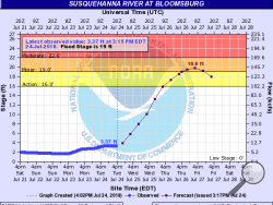
The National Weather Service has bumped up its predicted river crest for Thursday in Bloomsburg.
As of Tuesday evening, the NWS was predicting the Susquehanna River at Bloomsburg would reach 19.8 feet on Thursday afternoon. That's about 0.3 feet higher than its prediction from earlier in the day.
Meteorologist Michael Colbert of the service's State College office said the forecast jumped because more rain than expected fell in the area that sends its water to the Susquehanna in Bloomsburg.
With another day of rain predicted for Wednesday, Colbert said there remains some possibility for the predicted crest to jump higher – or go lower.
"There's always some uncertainty in predicting the weather," Colbert said. "And doing a river forecast is one step more complicated."
But the past few river forecasts have remained fairly steady, "so I'm not expecting that to change much."
While the river should hit its highest point Thursday, that's also the day that the weather system that has been dumping water on eastern Pennsylvania since Sunday should begin to break up, Colbert said. By Thursday afternoon, forecasts have the chance of rain dropping to 10 percent.
The 19.8-foot predicted crest is still well below the devastating 32.75 foot crest of 2011 or even the destructive crests of 28.64 feet in 2006 or 27.12 feet in 2004.
3 P.M. UPDATE
Danville borough crews nearly shut down Route 11 Tuesday morning to protect the neighborhood from rising floodwaters. In cases of high water, crews install a floodwall closure across the highway. And Tuesday morning, Mahoning Creek came within a foot or two of the Route 11 bridge that spans it, said borough EMA coordinator Richard Blosky.
“Just like in 2011, Mahoning Creek went crazy,” Blosky said. He said workers were considering installing the closure, which shuts down the road, to prevent flooding to the Danville Middle School and surrounding areas.
But the water never went over the bridge.
And unless Danville gets hit with another downpour, Blosky said he was hopeful that the creek wouldn’t pose a problem.
The borough is keeping its pumping station on Sechler Run manned around the clock with street department employees. The pumps in the pumping station ensure the run doesn’t overflow. Sechler Run flows into town from Mahoning Township and empties into Mahoning Creek near the borough hall.
2:10 P.M. UPDATE
In Bloomsburg, Fire Chief Scott McBride says his department had a meeting Monday night to prepare for possible high water, and they have all of their pumps checked out and ready to pump out basements if needed.
With many new volunteers since the 2011 flood, some of the meeting was spent giving reminders — like if you're responding to a flood call, don't wear heavy fire gear and make sure to wear a life jacket.
So far, Bloomsburg Fire Department hasn't had any calls to bail out a basement, "but there's still a bunch of rain coming."
1:43 P.M. UPDATE
Columbia County Resiliency Officer Eric Stahley, who oversees the floodwall that protects Autoneum and the former Windsor Foods plant, says officials are keeping an eye on weather forecasts, but aren't taking steps yet to install closures in the flood protection system.
Three gates that face Fishing Creek don't need any intervention. They are buoyant, and automatically rise if the creek flash floods, Stahley said.
Floodwaters don't threaten another closure, near the horse barn, until the river approaches 21 feet, Stahley said. That's higher than the 19.5 foot crest the National Weather Service currently expects.
"Of course, we'll be monitoring it," Stahley said. "Just because the National Weather Service says it will top off at 19.5 feet doesn't mean it will."
1:30 P.M. UPDATE
As rain continued to fall Tuesday, creeks rose, closing a batch of roads in Montour County, and a few in Columbia as well.
The rain also caused the National Weather Service increased its expected river flood crest — it now expects the river to top out at 19.5 feet Thursday afternoon in Bloomsburg.
That's high enough that the Susquehanna River would spill its banks, flooding some homes on Fort McClure Boulevard, and possibly causing some of the Bloomsburg Fairgrounds to flood. But it's well below the devastating 32.75 foot crest of 2011 or even the destructive crests of 28.64 feet in 2006 or 27.12 feet in 2004.
Today, creeks are the problem, not the river. Here's a list of the current road closures in Montour County, as of 1 p.m.
Anthony Township
Arrowhead Road (between PA-54 and PPL Road)
Derry Township
PPL Road (between Arrowhead Road and the Talen Energy Montour Plant)
Stamm Road (between Magargle Road and Strawberry Ridge Road)
Crawford Road (between Diehl Road and PA-254)
Steffens Road (between PA-254 and Hillside Road)
PA-254 (between PPL Road and PA-54)
PA-54 (between PA-254 and the I-80 interchange in Valley Township)
Valley Township
PA-54 (between the I-80 interchange and PA-254 in Derry Township)
Old Valley School Road (between PA-642 and Bennett St)
Liberty Township
Klondike Road (between PA-642 and the I-80 overpass)
In addition, the following locations are also closed:
Montour Preserve
Hess Recreation Area
Hopewell Park
North Branch Canal Trail
In Columbia County, the county EMA said Creek Road in Hemlock Township and Valley Road in Madison Township were both closed.
Check back throughout the day. We'll have more on preparations for high water.

